Interpreting the CAIC Avalanche Forecast

When you are planning a trip into the backcountry, always check the avalanche forecast before you head out. What is the avalanche forecast, you ask? Well, in the state of Colorado, we are home to the Colorado Avalanche Information Center or CAIC for short. The CAIC lives within the Colorado Department of Natural Resources and is charged with providing avalanche information for 10 different mountain regions across the state of Colorado. In addition, CAIC is passionate about avalanche education and providing recreationalists with the most up-to-date information so that they can enjoy the backcountry safely.
Everyday during the winter months, the CAIC publishes an avalanche forecast for the following regions:
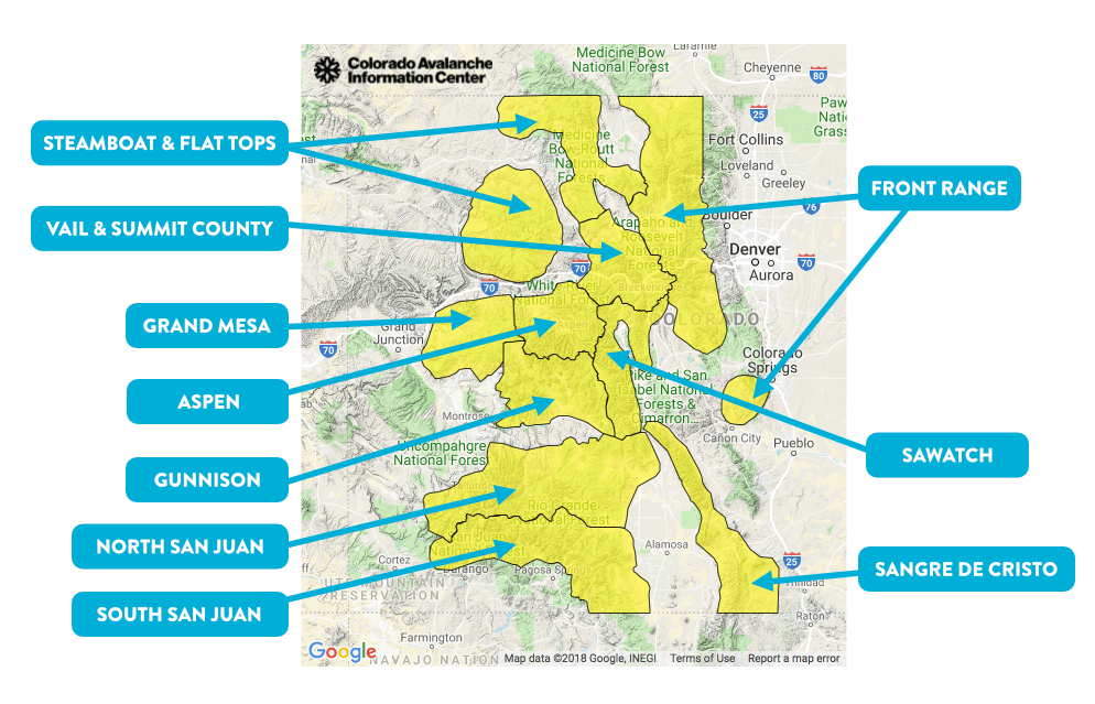
Source: CAIC
(Grand County falls in the Front Range region.)
You can find the avalanche forecast for your region on the CAIC website.
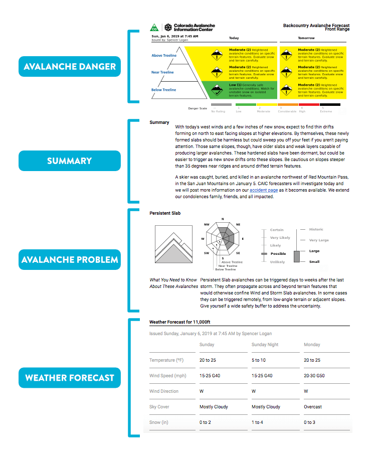
When looking at any of the forecasts, you’ll see that there are four main sections:
- Avalanche Danger below, near, and above treeline for today and tomorrow.
- A paragraph Summary of the current conditions.
- The main Avalanche Problem as well as the slope aspect and elevation of where the problem is likely to occur, how likely it is for that avalanche problem to occur, and what size that avalanche would be if it did occur.
- Weather Conditions for today and tomorrow.
Source: CAIC
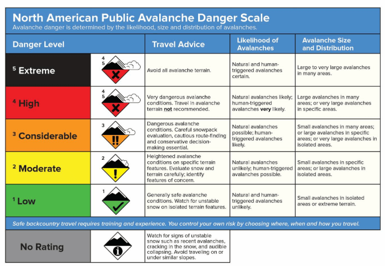
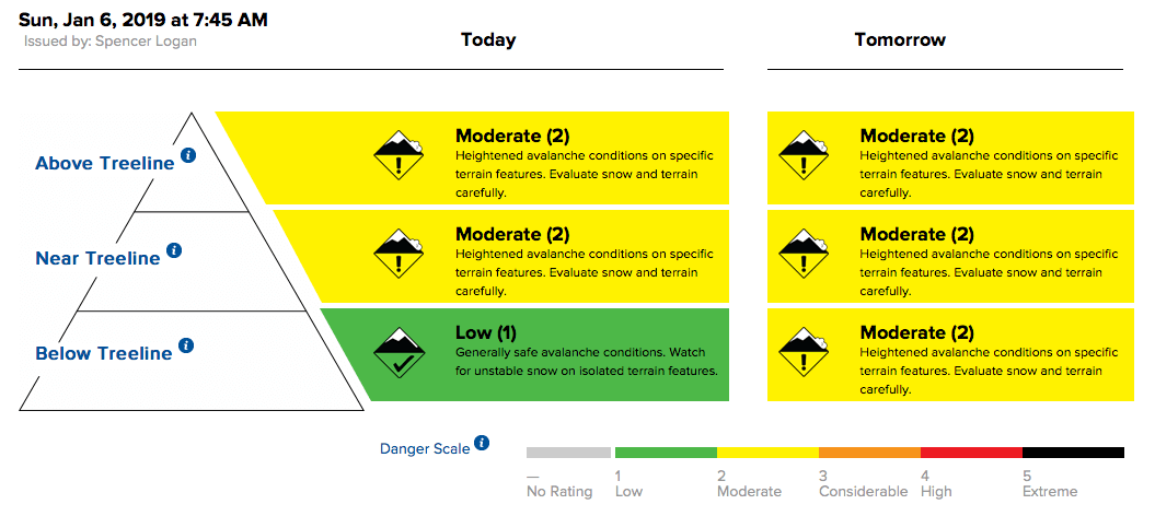
Avalanche Danger
The CAIC uses the North American Avalanche Danger Scale. When rating avalanche danger in the backcountry, three factors are taken into consideration: the likelihood of an avalanche, its size, and its distribution.
Source: CAIC
When you look at the avalanche forecast for your area, you’ll see that a danger rating is given below, at, and a above treeline, which helps for trip planning purposes. Below is the Avalanche Danger for the Front Range on January 6, 2019:
Source: CAIC
Summary
The next section of the Avalanche Forecast is the Summary. The Summary goes into more detail about what the avalanche forecaster is seeing in the field and the reasoning behind the assigned avalanche danger. When planning your trip into the backcountry, read the forecast summary carefully and make note of anything that might cause you to alter or change your anticipated route. Below is the Summary for the Front Range for January 6, 2019: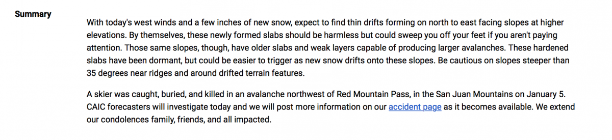
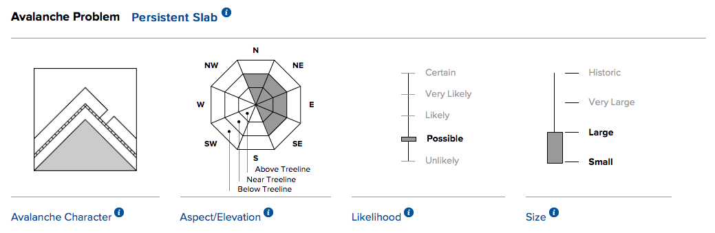
Avalanche Problem
Avalanche Problem details the type (or types) of potential avalanche that you may encounter during your backcountry travels. This is the Avalanche Problem for January 6, 2019:
Source: CAIC
The first thing you will see under Avalanche Problem is the character of the avalanche that is most likely to occur in the backcountry and its icon. In the example above, the avalanche problem for January 6, 2019 is Persistent Slab.
The Persistent Slab is just one of 9 types of avalanche problems:
- Loose Dry
- Storm Slab
- Wind Slab
- Persistent Slab
- Deep Persistent Slab
- Loose Wet
- Wet Slab
- Cornice Fall
- Glide
In addition to the main type of avalanche, we are give an Aspect/Elevation diagram of where we can expect to encounter this type of avalanche. In our example, we see that conditions for Persistent Slab avalanches are present near and above treeline on North, Northeast, East, and Southeast slopes.
Next we are given the likelihood that a Persistent Slab avalanche might occur, and if it does occur, how big the avalanche might be.
When planning your trip into the backcountry, take in to consideration all of these factors. If avalanche danger is high on a certain slope aspect, avoid traveling on those slope aspects for your upcoming trip.
If you still have questions about how to decipher the Avalanche Problem section of the Avalanche Forecast, check out this awesome video produced by the National Avalanche Center: Avalanche Problems Explained
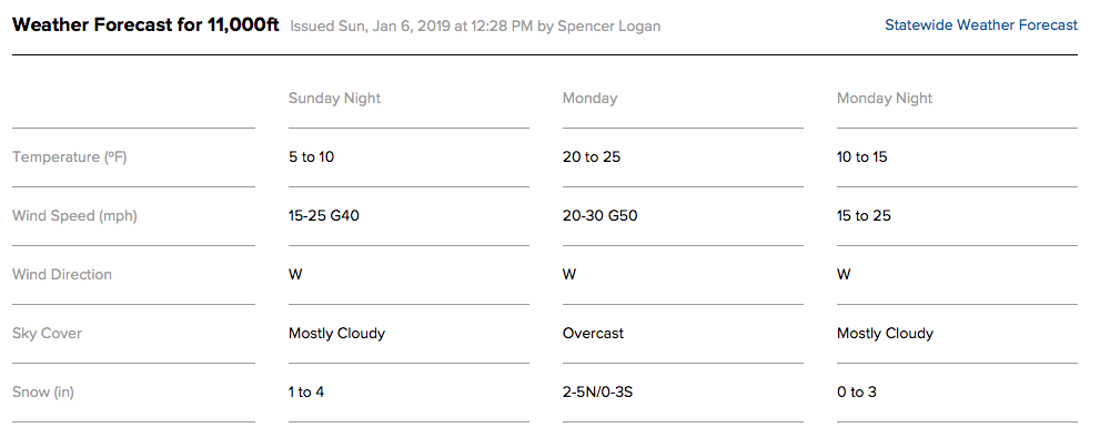
Weather Forecast
The final section of the Avalanche Forecast is the Weather Forecast. This section will give you a good idea of what type of weather you might encounter in the backcountry. Not only does it list temperature and wind speed, but it also tells you the direction of the wind, sky cover, and precipitation. Below is the Weather Forecast for the Front Range for January 6, 2019:
Source: CAIC
Final Thoughts
When reading the Avalanche Forecast, use it as a tool to help you plan your trip into the backcountry and manage potential risk. The backcountry is not patrolled like a ski area. It is up to you to gather all the information you can about past and current conditions to plan the safest trip possible. Remember when traveling in the backcountry to always carry and know how and when to use a beacon, shovel, and probe. For more information about current avalanche conditions in the state of Colorado visit the Colorado Avalanche Information Center.